| Maps of Missions, Trails & El Camino Real The True History of California Starts Here... |
 05-04-09, 03:47 PM
| #1 |
 
Join Date: 04-02-09
Location: San Diego County
Posts: 856
 |
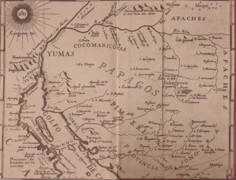
Map drawn from details gathered approx. 10 years earlier, in 1747. Eruption of Tres Virgenes volcano is noted (1746) and La Paz mission was still located on the bay (moved in 1748).
__________________
Visit my web site: David K's BAJA Adventures Order a copy of our NEW BOOK 'The Old Missions of Baja & Alta California' http://oldmissions.com |
|
06-02-09, 06:55 PM
| #2 |
|
Join Date: 04-02-09
Location: San Diego County
Posts: 856
|
Any lost mission hunters out there? This map has two... and one was discovered in 1966, maybe!
__________________
Visit my web site: David K's BAJA Adventures Order a copy of our NEW BOOK 'The Old Missions of Baja & Alta California' http://oldmissions.com |
|
 Similar Threads
|
||||
| Thread | Thread Starter | Forum | Replies | Last Post |
| JESUIT EL CAMINO REAL (Part 1: Santa Maria to San Borja) | David K | Maps of Missions, Trails & El Camino Real | 2 | 05-13-09 03:16 PM |
| JESUIT EL CAMINO REAL (Part 5: Guadalupe to Loreto) | David K | Maps of Missions, Trails & El Camino Real | 0 | 05-09-09 09:09 AM |
| JESUIT EL CAMINO REAL (PART 4: San Ignacio to Guadalupe) | David K | Maps of Missions, Trails & El Camino Real | 0 | 05-05-09 10:16 PM |
| JESUIT EL CAMINO REAL (PART 3: Santa Gertrudis-San Ignacio) | David K | Maps of Missions, Trails & El Camino Real | 0 | 05-05-09 10:01 PM |
| JESUIT EL CAMINO REAL (Part 2: San Borja to Santa Gertrudis) | David K | Maps of Missions, Trails & El Camino Real | 0 | 05-04-09 07:58 PM |
All times are GMT -7.
Powered by vBulletin® Version 3.8.3
Copyright ©2000 - 2014, Jelsoft Enterprises Ltd.
Archived 2014
Copyright ©2000 - 2014, Jelsoft Enterprises Ltd.
Archived 2014