| Maps of Missions, Trails & El Camino Real The True History of California Starts Here... |
 11-19-10, 10:50 AM
| #1 |
 
Join Date: 04-02-09
Location: San Diego County
Posts: 856
 |
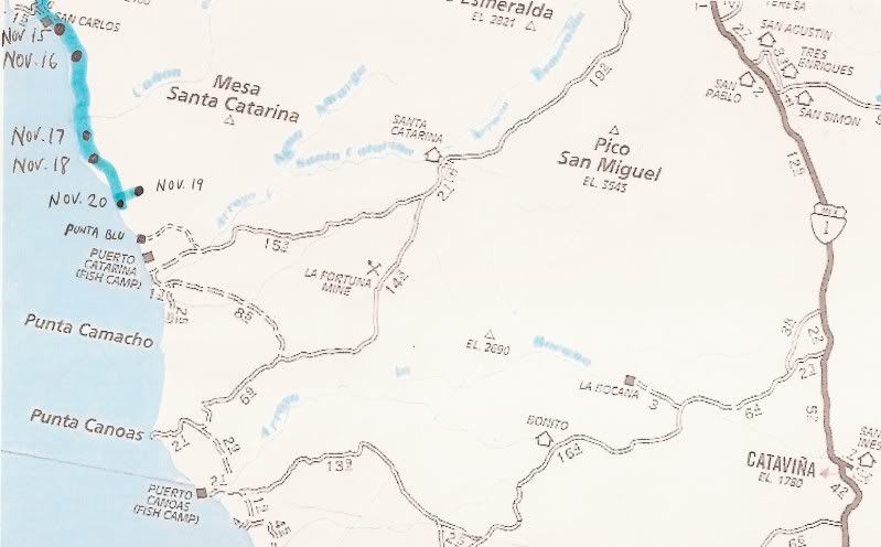
Each date point on the map comes from Mike's GPS SPOT locator. The blue line indicates his probable route between the points.
The complete story with photos has been running on Baja Nomad if you are not familiar with this adventure: BajaNomad Forums - "Peace, Love & Fish Tacos" 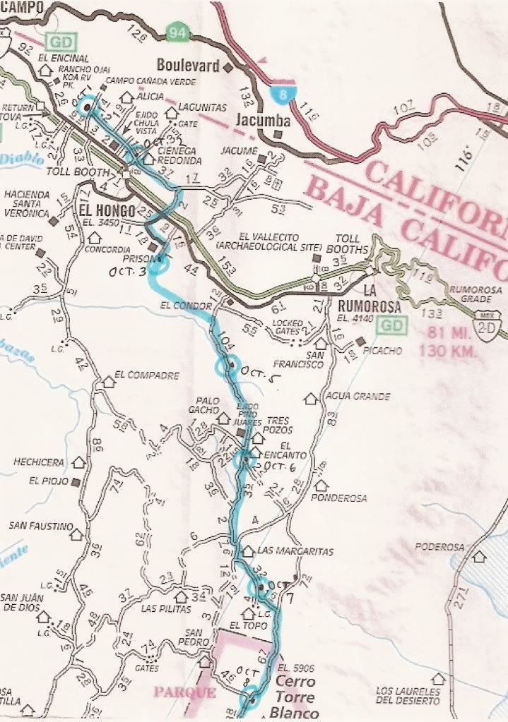 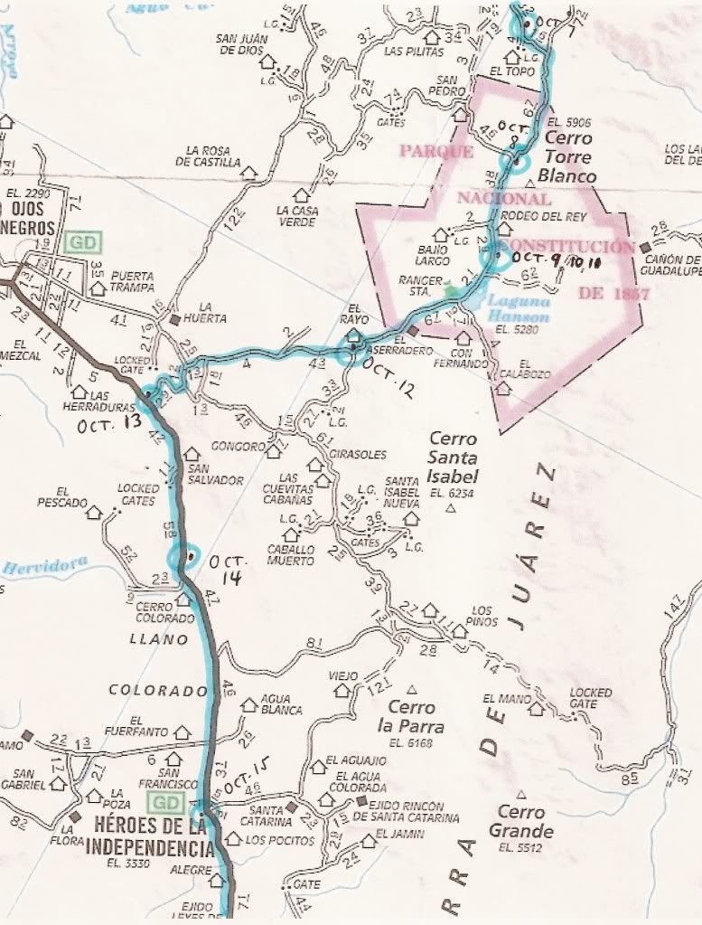 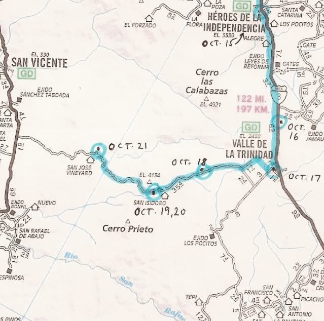 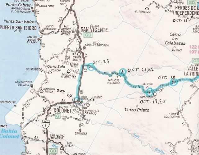 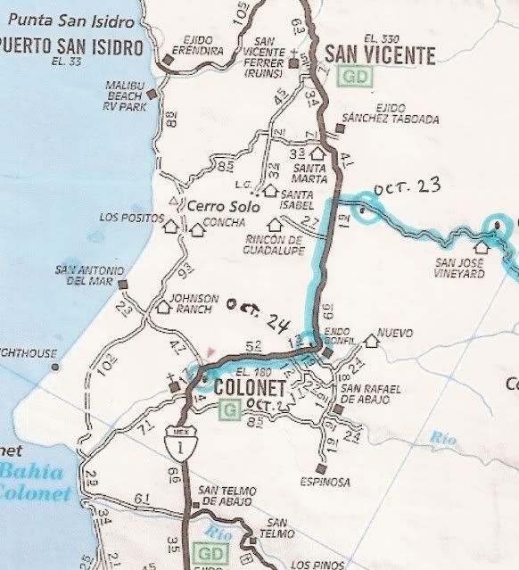 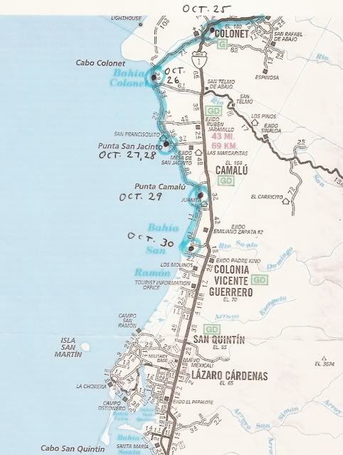 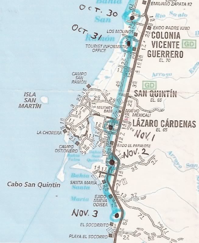 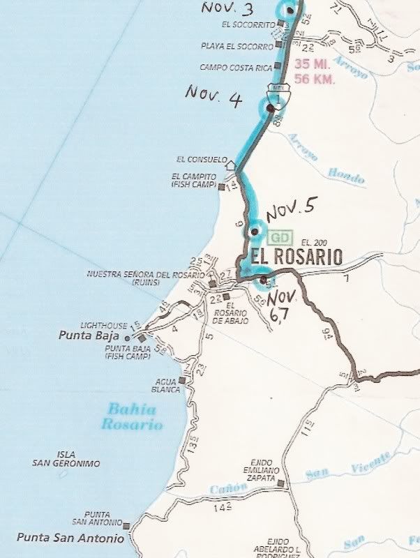 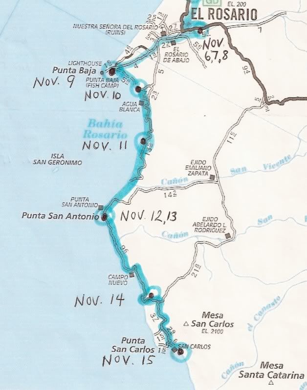 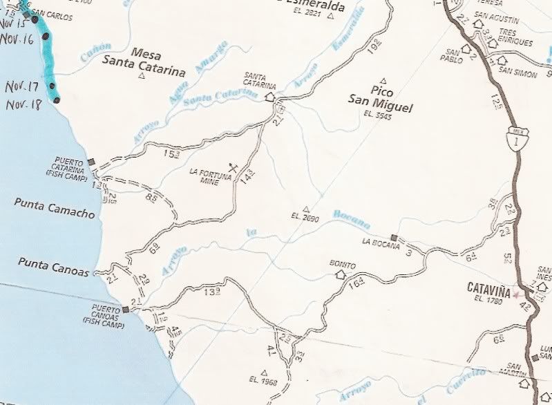 To Be Continued!
__________________
Visit my web site: David K's BAJA Adventures Order a copy of our NEW BOOK 'The Old Missions of Baja & Alta California' http://oldmissions.com |
|
11-19-10, 11:17 AM
| #2 |
 
Status: Queso Grande
Join Date: 02-09-09
Location: San Quintin
Posts: 7,148
|
Cool summary. Thanks DK (the one with only 2 legs)

__________________
TalkBaja.com - Where everybody knows your name and nobody stays on topic... |
|
11-20-10, 11:21 AM
| #3 | |
|
Join Date: 04-02-09
Location: San Diego County
Posts: 856
|
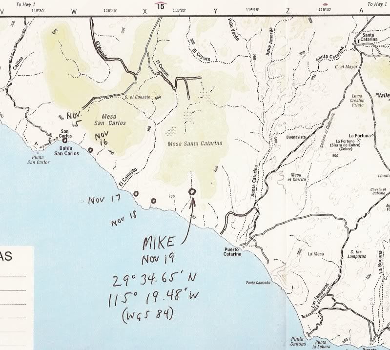 Message from SPOT on 11-19-10: Quote:
__________________
Visit my web site: David K's BAJA Adventures Order a copy of our NEW BOOK 'The Old Missions of Baja & Alta California' http://oldmissions.com |
|
|
11-20-10, 12:24 PM
| #4 |
|
Join Date: 04-02-09
Location: San Diego County
Posts: 856
|
posted on 11-20-2010 at 11:09 AM
MIKE IS SAFE AND HAS BEEN FOUND !!!!!!!!!!! HE AND ALL ARE OK REPORT TO FOLLOW SOON NEIL
__________________
Visit my web site: David K's BAJA Adventures Order a copy of our NEW BOOK 'The Old Missions of Baja & Alta California' http://oldmissions.com |
|
11-20-10, 12:36 PM
| #5 |
 
Join Date: 06-23-09
Location: BCS
Posts: 1,536
|
Whew! Been checking on this since it began! Was really worried that something had happened to Don-Kay!
Hang in there both of you!!!!!!! |
|
11-20-10, 01:34 PM
| #6 |
|
Join Date: 04-02-09
Location: San Diego County
Posts: 856
|
posted on 11-20-2010 at 12:09 PM
Ok so we all deserve a big round of applause for the team effort that went into locating Mike & Co. this morning. If it weren't for David K's google map and Kevin deciding on the best course of action this could have been a major cluster f@ck. The discussions and teamwork here was invaluable. Thank you everyone ! So here is the condensed version: Early this morning I made a copy of David's Google earth map indicating his last reported position. I packed water (5 gal), food/first aid, GPS and headed down to the local fish camp. Radio'd on the VHF and Alfredo responded and came to the beach right away. Apprised him of the situation and within 15 minutes we were steaming down the coast. Very fortunate as the seas are down and the wind is light. After nearly 20 km we came towards the arroyo that hits the beach below Mike's last coordinate and there they were. He had moved down the arroyo next to the beach. Good move Mike ! . Mike and Co. had run out of water. Don-Kay had gone on strike and they all were exhausted from this extremely challenging section of his journey. He told me that our arrival was like the coming of Christ. he had to rub his eyes and make sure he wasn't seeing things. He is in great spirits now and definitely recognizes he is responsible for actions but he didn't expect how tough this section would be with a burro. Hiking it on his own would have been easy compared to towing a burro he said. He says hello to everyone and wants us to know that HE THANKS US FROM THE BOTTOM OF HIS HEART and is fortunate that technology is what it is today. Wihout a doubt, on his own with no chance of aid, he would have been in big trouble. The humor of the morning was that when I told him of the potential weather to the North(may or may not rain here) we laughed hard that "It figures it might rain right after water is delivered to him !" So he is about a 6 miles to the first of many fish camps on the coast and hopes he can make it by days end. He has water to keep Don-Kay, Solo and himself going for a 3-4 days. It was the best I could do and I will continue to monitor his position at the end of today. He was reminded not to forget the end of day position. Feliz Viente Noviembre ! Viva la Mexico ! Best regards, Neil at Solosports >>> RON, (BajaGringo) COME HOME!
__________________
Visit my web site: David K's BAJA Adventures Order a copy of our NEW BOOK 'The Old Missions of Baja & Alta California' http://oldmissions.com |
|
11-20-10, 01:37 PM
| #7 |

Join Date: 04-06-09
Location: La Paz, BCS
Posts: 553
|
Wonderful news, indeed!!

|
|
11-20-10, 02:39 PM
| #8 |
 
Join Date: 08-14-09
Location: Loreto, B.C.S.
Posts: 226
|
And now we're waiting on news from Ron.
Hope he's alright. |
|
11-20-10, 02:56 PM
| #9 |
|
Join Date: 04-06-09
Location: La Paz, BCS
Posts: 553
|
It didn't seem to me that Ron was heading down there on his own. One of his last posts on BN indicated that he was going to the SQ police, and from there they were going to work with people from El Rosario to get help to Mike.
"I just spoke with the local San Quintin police and after telling them the story they asked me to head over with all the info. They said they will try and help us coordinate with folks from El Rosario to put together a group to reach Mike." |
|
11-20-10, 05:46 PM
| #10 | |
 
Status: `
Join Date: 05-08-09
Posts: 3,676
|
Let's see here...
Ron + Saturday night in San Quintín... I bet he's a little more than just "all right"... The real hero in this is Don-Kay: Quote:

|
|
|
11-20-10, 07:48 PM
| #11 | |

Join Date: 04-07-09
Posts: 1,526
|
Quote:
Por-Kay.....Don't freakin get it, Marty, my man. Am I just stooopid, or waaaaat? Reminds me of the mine drama in Chile when the men were rescued from their grave-to-be at a mile below a level that any man should allow himself to be....except plumbers, who don't count. [anyone who gets paid to play with the container of recycled burritos doesn't count] Anyway...who was the hero in the mine incident? The miner or the savior? The savior...of course. But, are they on Oprah? No way. The miners are on Oprah and that's crazy. In fact, Oprah is on Oprah and that's just as crazy. Let's get this stuff straight. That unstudied adventurer in Baja isn't the hero in this drama. Ron, and those other guys who came to the rescue are the heroes. We all see that, so why can't we see it with the miners in Chile??? |
|
|
11-20-10, 08:12 PM
| #12 |
|
Status: `
Join Date: 05-08-09
Posts: 3,676
|

|
|
11-20-10, 09:59 PM
| #13 |
|
Join Date: 04-02-09
Location: San Diego County
Posts: 856
|
__________________
Visit my web site: David K's BAJA Adventures Order a copy of our NEW BOOK 'The Old Missions of Baja & Alta California' http://oldmissions.com |
|
11-21-10, 08:51 AM
| #14 |
|
Status: Queso Grande
Join Date: 02-09-09
Location: San Quintin
Posts: 7,148
|
This is what Mike and Don-Kay will see as they come around the point towards the Punta Azul fish camp. I am sure that the beach will be a welcome site after the rock ledge they have been traversing...
__________________
TalkBaja.com - Where everybody knows your name and nobody stays on topic... |
|
11-21-10, 12:19 PM
| #15 |
|
Join Date: 05-24-09
Location: La Paz
Posts: 1,682
|
You & Duro did good!!
 As did solosancarlos & company! As well as the local authorities & various individuals who were involved! IMO, everybody "on the ground" who kicked into action to attempt to physically locate Mike, DonKay & Solo (the 4-legged one!)  are hero's in my book. are hero's in my book. I agree with what I believe Marty is trying to say, I feel that DonKay is trying to tell Mike he's reached the limits of his endurance & either needs a lighter load, more rest, better nutrition, more water....or all of the above. DonKay has gone from being fed a decent diet on a regular schedule to having to forage for what he can find under the worst of conditions. They're a team....they both need to listen to the other to make this arduous journey a success!! |
|
11-21-10, 01:17 PM
| #16 |

Join Date: 04-07-09
Location: Southern California
Posts: 623
|
All I can say is I am happy that Mike and his donkey are ok. A big thank you to the first responders from San Carlos who got to him and to Ron BajaGringo and his co-pilot Duro for giving a valiant effort to get to them too. You all went above and beyond the call of duty giving of yourselves by putting yourselves in danger to rescue others without thought of reward. You guys are my heroes. I'm just so very happy everyone made it out ok.
__________________
I David Elinvestig8r M. do hereby exercise my rights under the First Amendment to freely express myself here on TalkBaja in as much as I am allowed to do so by BajaGringo! Well... 
|
|
11-21-10, 01:25 PM
| #17 | |
|
Status: `
Join Date: 05-08-09
Posts: 3,676
|
Here are the next three days' tides/San Diego. Close to what is happening there.
Quote:
Even with those somewhat-negative low tides, beaching it might not work. Yes, there would be long, blissful stretches of smooth hardpack. But at the ends of those where headland comes down, there is usually very, very tricky/slippery shelf and/or smooth round rock. A man can do it, but only with quite a bit of care. Not a heavily-loaded pack mule. Plus it could be late afternoon if they didn't hit it just as the tide starts down(say about noonish); facing dwindling daylight and an unsure path to ascend off the beach... I wouldn't risk a long backtrack with the burro if I weren't pretty sure we could get up on the far end... Tonight's ping will be revealing; if they have moved or if they haven't. |
|
|
11-21-10, 01:59 PM
| #18 | |
|
Status: Queso Grande
Join Date: 02-09-09
Location: San Quintin
Posts: 7,148
|
Quote:
Legs is right - that poor animal needs some real R&R after the past several days. That path was not made for a pack animal and I would guess that Mike would rethink it knowing what he does now. Hindsight is always 20-20 as they say. Slow and sure Mike and let's get this stretch of road behind us...
__________________
TalkBaja.com - Where everybody knows your name and nobody stays on topic... |
|
|
11-21-10, 02:27 PM
| #19 |
|
Join Date: 05-04-09
Location: Too often not South of the border
Posts: 2,375
|
Amplifying a bit on Dennis' post, I do have to conclude that Mike made a possibly foolish decision to do what he is doing, and in the course of things, is causing many others to become complicit. Hats off to those who have helped, or tried to help. But, at the end of the day, as I believe Dennis used the term "unstudied", any misfortune that may occur is clearly on Mike's shoulders. And God forbid any possible misfortune would extend to any samaritans.
|
|
11-21-10, 04:14 PM
| #20 |
|
Join Date: 04-02-09
Location: San Diego County
Posts: 856
|
Perhaps you should read the newspaper article or Graham Mackintosh's replies about Mike... He has been preparing quite some time for this voyage. It was not a sudden whim to undertake such an adventure.
This coastal section between San Carlos and Santa Catarina is the longest that isn't near any roads. I believe once he has passed Punta Canoas, he can walk on roads the rest of the trip.
__________________
Visit my web site: David K's BAJA Adventures Order a copy of our NEW BOOK 'The Old Missions of Baja & Alta California' http://oldmissions.com |
|
 Similar Threads
|
||||
| Thread | Thread Starter | Forum | Replies | Last Post |
| Baja Maps from the past! | David K | Maps of Missions, Trails & El Camino Real | 56 | 04-15-14 11:32 PM |
| Mike and Don-Kay Baja Trek 2010-2011 | David K | Baja Photo Uploads / Trip Reports | 272 | 07-03-13 08:52 PM |
| Give Baja for Christmas! Gift book 'In the Shadow of the Volcano' by Mike Humfreville | David K | General Classified Ads | 13 | 09-15-12 07:37 PM |
| Mike and Don-Kay nearing Baja Gringo's | David K | Baja Photo Uploads / Trip Reports | 28 | 11-08-10 05:22 PM |
All times are GMT -7.
Powered by vBulletin® Version 3.8.3
Copyright ©2000 - 2014, Jelsoft Enterprises Ltd.
Archived 2014
Copyright ©2000 - 2014, Jelsoft Enterprises Ltd.
Archived 2014