| Maps of Missions, Trails & El Camino Real The True History of California Starts Here... |
 04-20-09, 08:58 AM
| #1 |
 
Join Date: 04-02-09
Location: San Diego County
Posts: 856
 |
As a collector of books and maps of Baja California... I am happy to share my collection with fellow Baja enthusiasts.
Let me know what you would like to see! First, the most valuable maps those of us had who statred going to Baja in the 1960's were those drawn by Howard Gulick... author of the Lower California Guidebook. My friend Doug Eernisse, made a web page to show Howard's maps... Just click on the peninsula map on this link to see a close up map of that area: http://biology.fullerton.edu/biol517...baja_1962.html This 1905 mining map of northern Baja is pretty interesting:  Here's a 1941 Baja transpeninsular road map:  One of my favorites is this 1930 Baja wall map:  The Jesuit's 1757 map showing the missions, including 2 'lost' missions is popular: 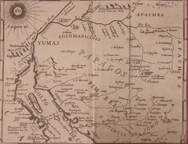 In 1927, the Auto Club had maps showing the road from Tijuana to El Rosario:  This rare map from the Bancroft Library collection was made by Jesuit padre and explorer Eusebio Francisco Kino in 1702... Perhaps the first to correctly show California as a peninsula. Maps still continued to be made that shows it as an island for many decades after. Note that the missions of Loreto and San Xavier are on the map, the only ones until 1705 when Ligui and Mulege were founded.  I have more, stay tuned!... Also, I am happy to provide a close up of any spot on Baja from any map I have!
__________________
Visit my web site: David K's BAJA Adventures Order a copy of our NEW BOOK 'The Old Missions of Baja & Alta California' http://oldmissions.com |
|
04-24-09, 08:19 AM
| #2 |
|
Join Date: 04-02-09
Location: San Diego County
Posts: 856
|
Gracias Baja Gringo for adding the tags to show the maps... The above is a tiny sampling of what I have scanned from my books and maps collection. Any Talk Baja members who would like to see more or a close up of any part of any map... I am happy to provide you with it!
__________________
Visit my web site: David K's BAJA Adventures Order a copy of our NEW BOOK 'The Old Missions of Baja & Alta California' http://oldmissions.com |
|
04-24-09, 10:21 AM
| #3 |
 
Status: Queso Grande
Join Date: 02-09-09
Location: San Quintin
Posts: 7,148
|
David, you know what I like...
ANYTHING from the Colonet - Camalu - San Quintin - El Rosario area... 
__________________
TalkBaja.com - Where everybody knows your name and nobody stays on topic... |
|
04-25-09, 10:36 AM
| #4 |
|
Join Date: 04-02-09
Location: San Diego County
Posts: 856
|
Here's a selection for you Ron:
1888:  1905:  1919 (from 1905 survey):  1919:  1927: 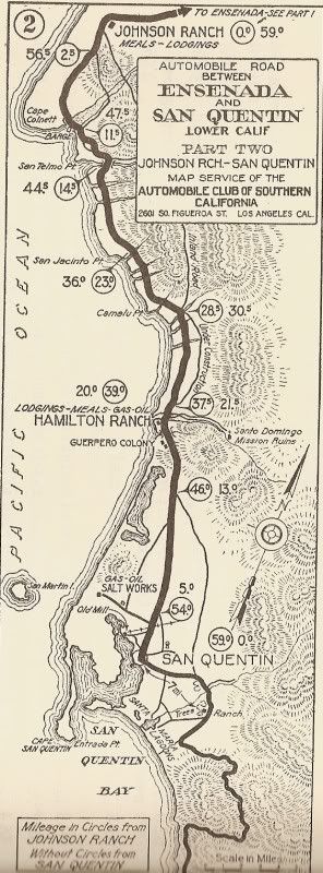 1930:  1941:  1962 north:  1962 south:  Let me know if you need more or closer in of any!
__________________
Visit my web site: David K's BAJA Adventures Order a copy of our NEW BOOK 'The Old Missions of Baja & Alta California' http://oldmissions.com |
|
04-25-09, 11:06 AM
| #5 |
|
Status: Queso Grande
Join Date: 02-09-09
Location: San Quintin
Posts: 7,148
|
Thanks David - those are great!
__________________
TalkBaja.com - Where everybody knows your name and nobody stays on topic... |
|
04-29-09, 10:22 PM
| #6 |
 
Join Date: 04-16-09
Posts: 38
|
David, you got any detailed maps of the Valle de Trinidad area?
Thanks! |
| David K |
|
This message has been deleted by David K.
|
|
05-02-09, 07:08 AM
| #7 |
|
Join Date: 04-02-09
Location: San Diego County
Posts: 856
|
Gracias!
__________________
Visit my web site: David K's BAJA Adventures Order a copy of our NEW BOOK 'The Old Missions of Baja & Alta California' http://oldmissions.com |
|
08-22-09, 08:10 AM
| #8 | |
|
Join Date: 04-02-09
Location: San Diego County
Posts: 856
|
Quote:
Here are maps from 1905, 1962, 1919, 1930, and 1941 showung Valle de Trainidad
__________________
Visit my web site: David K's BAJA Adventures Order a copy of our NEW BOOK 'The Old Missions of Baja & Alta California' http://oldmissions.com |
|
|
08-22-09, 08:13 AM
| #9 |
|
Join Date: 04-02-09
Location: San Diego County
Posts: 856
|
Here is Valle de Trinidad on an 1888 map!
__________________
Visit my web site: David K's BAJA Adventures Order a copy of our NEW BOOK 'The Old Missions of Baja & Alta California' http://oldmissions.com |
|
03-11-10, 09:30 AM
| #10 |
|
Join Date: 04-02-09
Location: San Diego County
Posts: 856
|
I am still fielding requests for close ups on any of the old maps...
__________________
Visit my web site: David K's BAJA Adventures Order a copy of our NEW BOOK 'The Old Missions of Baja & Alta California' http://oldmissions.com |
|
03-11-10, 12:53 PM
| #11 |
 
Join Date: 10-24-09
Posts: 423
|
Any from the Puerto Nuevo area?
|
|
03-12-10, 06:12 PM
| #12 | |
|
Join Date: 04-02-09
Location: San Diego County
Posts: 856
|
Quote:
__________________
Visit my web site: David K's BAJA Adventures Order a copy of our NEW BOOK 'The Old Missions of Baja & Alta California' http://oldmissions.com |
|
|
01-05-11, 01:23 AM
| #13 |
 Join Date: 01-05-11
Posts: 3
|
Hi, excellent maps you have,
do you have some maps of Bahia de los Angeles area? Thanks |
|
01-10-11, 03:46 PM
| #14 |
|
Status: Queso Grande
Join Date: 02-09-09
Location: San Quintin
Posts: 7,148
|
Here is a map DavidK has previously posted that I like. Are you looking for more detailed maps of a certain area???
.
__________________
TalkBaja.com - Where everybody knows your name and nobody stays on topic... |
|
01-10-11, 06:36 PM
| #15 |
 
Join Date: 01-17-10
Location: Mission Viejo
Posts: 2,523
|
The map-meister

__________________
Suicide hot line... please hold |
|
01-10-11, 09:14 PM
| #16 | |
|
Join Date: 04-02-09
Location: San Diego County
Posts: 856
|
Quote:
I am not sure how to put captions under each map when they are uploaded through Baja Gringo's software? The 10 maps showing Bahia de los Angeles are: 1757 1864 1888 1905 1919 1930 1941 1962 1975 2007 Okay, I previewed, and the maps are not being shown in order as listed... The top one (just below) 1864 then below it is: 1941, 1905, 1919, 1930, 1962, 1975, 2007, 1757, 1888, 1941.
__________________
Visit my web site: David K's BAJA Adventures Order a copy of our NEW BOOK 'The Old Missions of Baja & Alta California' http://oldmissions.com |
|
|
01-11-11, 09:53 AM
| #17 |

Status: `
Join Date: 05-08-09
Posts: 3,676
|
So this one; 1962 eh?
I talked to someone from El Rosario who knows that place as El Muertito. |
|
01-11-11, 11:20 AM
| #18 | |
|
Join Date: 04-02-09
Location: San Diego County
Posts: 856
|
Quote:
Do you know why the maps I posted in order are showing up scrambled? Can you (or I) do something to fix them. Otherwise, when I have time I will delete them and post from Photobucket... that way I can add captions under each picture (the date, etc.).
__________________
Visit my web site: David K's BAJA Adventures Order a copy of our NEW BOOK 'The Old Missions of Baja & Alta California' http://oldmissions.com |
|
|
01-11-11, 11:46 AM
| #19 | |
|
Status: Queso Grande
Join Date: 02-09-09
Location: San Quintin
Posts: 7,148
|
Quote:
Then you can just right click on any image there, copy the image location and post it here on the forum using the post image tool above and place comments inline. Does that make sense???
__________________
TalkBaja.com - Where everybody knows your name and nobody stays on topic... |
|
|
01-14-11, 03:54 PM
| #20 |
Join Date: 04-06-09
Location: Baja South
Posts: 116
|
In the lower left corner of this map is an interesting comment... "50,000 wild cats roam the island". Anybody know the history of that? |
|
 Similar Threads
|
||||
| Thread | Thread Starter | Forum | Replies | Last Post |
| Where Can We Find City Maps With Neighborhoods Marked? | Marty Cortez | General Discussion | 12 | 10-30-12 05:47 PM |
| MISSIONS over the years 1700 to 1840 on maps | David K | Maps of Missions, Trails & El Camino Real | 1 | 09-13-12 11:53 AM |
| Ensenada in decades past... | BajaGringo | Baja Photo Uploads / Trip Reports | 9 | 05-30-11 03:56 PM |
| Mike and Don-Kay Baja Trek 2010-2011 Maps | David K | Maps of Missions, Trails & El Camino Real | 82 | 12-13-10 09:06 PM |
| VALLE DE TRINIDAD MAPS 1888-1975 | David K | Maps of Missions, Trails & El Camino Real | 0 | 05-04-09 04:28 PM |
All times are GMT -7.
Powered by vBulletin® Version 3.8.3
Copyright ©2000 - 2014, Jelsoft Enterprises Ltd.
Archived 2014
Copyright ©2000 - 2014, Jelsoft Enterprises Ltd.
Archived 2014